The career that you are going to be involved in depends on both your talent as well as your preference. If you choose to become a surveying technician, through which you can go for a good income, this article is going to be a must-read for you. Of course, you would know that surveying technicians need certain tools that they need to use for their professional duties. Needless to say, each unique profession requires a set of unique tools. Also, certain tools are common to several professions. However, in this article, we are going to tell you about the tools of a surveying technician. So, even if you are not going to be a surveying technician, there is no harm in reading this. Indeed, you can broaden your knowledge by reading this.
What are the duties of Surveying Technicians?
However, before we tell you about the tools of a surveying technician, it is important to first understand what surveying technicians do. So, what are the responsibilities of surveying technicians? Surveying technicians are primarily responsible for land surveying and mapping, in the simplest terms.
Surveying professionals would have to go to different locations to collect data. Basically, they would have to utilize the appropriate surveying instruments and equipment. There is no doubt about that. And we will tell you all about those tools and equipment in this article. They would also have to think about the prior surveying points and factor them into the equation. Typically, a survey party consists of party chief and one or more surveying technicians. The survey chief is in charge of a surveying team’s day-to-day operations. A surveyor or a senior surveying technician serves as the chief. Following the survey team’s data gathering, surveying technicians aid in the data processing by inputting it into computers.
Generally, these are the duties of surveying technicians. We hope you understood what surveying technicians do, on the whole. So, we can move ahead in this article and get to know about the tools of a surveying technician.
Work Environment of Surveying Technicians
We think that it would be important to tell you about the work environment of surveying technicians as well. The majority of surveying technicians work for companies that contract out engineering, surveying, and mapping services. These professionals are also employed by local governments in highway and planning agencies.
Surveying technicians spend a lot of time outside. And they have to be exposed to a variety of weather conditions. They frequently stand for long periods of time, travel great distances, and may have to climb hills while carrying heavy surveying gear. Surveying technicians may have to drive great distances, remain away from home overnight, or even relocate near a survey site as part of their employment.
Surveying technicians usually work full-time. But during the summer, when the weather and light conditions are ideal for fieldwork, they may work longer hours. During inclement weather, it is impossible to carry on construction activities.
Basically, this is pretty much about the work environment of surveying technicians. We hope you grasped what we mainly needed to tell you.
Tools of a Surveying Technicians
Alright. Now, it is time to discuss the main content of this article; the tools of a surveying technician.
- Tripods
- Levels
- Total stations
- Theodolites
- Surveying magnetic locator
- Compasses and clinometers
- Distance measuring tools
- Ground-penetrating radars
- 3D laser scanners
- Safety vests
These are the basic surveying tools that we came up with. In fact, you would be anxious to know about each of these tools in particular. Do not worry! Let us tell you!
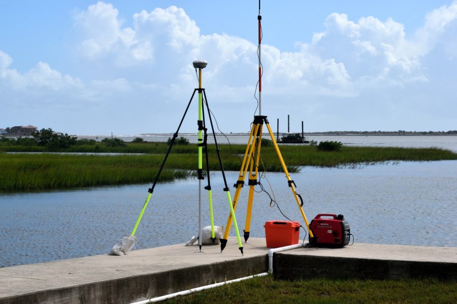
1. Tripods
In the main, it is the sight of a tripod with a man wearing a safety vest that tells an ordinary person that there is a surveyor in the vicinity. Tripods are that much relevant to the career of surveyors.
Basically, why do surveyors need tripods? Mainly, surveyors need tripods to support some sort of surveying instrument that the particular surveyor has to use. The surveying instrument might be a level, a total station, or a theodolite. We will discuss each of those surveying instruments separately in the next parts of this article. But surveyors use tripods to support those surveying instruments.
There are mainly two types of surveying tripods. They are adjustable-leg tripods and fixed-leg tripods. In adjustable-leg tripods, you have the ability to adjust the length of each leg out of the three separately. Notwithstanding, when it comes to fixed-leg tripods, you would no9t have that ability as the length of their legs is fixed and permanent. Of course, you would also understand that using adjustable-leg tripods is far more beneficial than using fixed-leg tripods. Fair enough, it is mainly the adjustable-leg tripods that surveyors use nowadays.
And there are elevating tripods. You can elevate the head of these tripods. And the head is rotatable. Hence, these are specifically useful when you are using rotating laser levels.
All the same, there are certain accessories that you can buy for a surveying tripod. They include laptop brackets, antenna brackets, tripod stabilizers, and umbrellas.
In addition to tripods, surveyors also use bipods. Depending on the circumstance, you can choose either a tripod or a bipod for the surveying tasks.
AdirPro Giant 157″ Aluminum Elevating Tripod – Heavy Duty Surveying Tools for Engineers and Land Surveyors
This is an elevating surveying tripod that we can recommend to you to buy. It has used heavy-duty aluminum in its manufacturing process to ensure long life. Also, it has a stable base which makes it very convenient for the user. And it quickens your mounting and it has a flat head as well. Considering all these factors, we think that this would be an ideal one for you to choose as a surveying tripod.
2. Levels
In terms of levels, surveyors particularly use a number of different types of levels. In the first place, they use hand levels as one of the tools of a surveying technician. Obviously, this is the most basic level of levels. Hand levels have a telescope and a bubble tube. You can see the bubble when you look through the telescope. By doing so, you can check it.
Next, surveying technicians use electronic levels. Surveying technicians can assure the accuracy of their work by using electronic levels when shooting grades and establishing elevations. With electronic levels, there is actually no chance for an error to occur. Of course, human errors do not occur during the calculation when you are using electronic levels. So, you would not have to worry about the accuracy of the results an electronic level displays.
Furthermore, surveyors use automatic levels. We sometimes refer to automatic levels as self-leveling levels. We do not think that there is any need to explain why we refer to it as self-leveling levels. That itself explains how accurate automatic levels are. It is mostly automatic levels that are in use in the modern-day. Nevertheless, the conventional levels are also in use up to a certain extent depending on the circumstance.
Leica Geosystems 840383 NA332 360 Degree Auto Optical Level
In terms of automatic levels, this would surely be a good one for you to buy. This is a water and dust-tight and impact-resistant automatic level. Its convenient operation and ergonomic design make this one of the best choices. There is plenty of positive feedback for this. Many buyers of this have admired factors like accuracy, value for money, lightweight, and ease of use.
3. Total stations
As one of the tools of a surveying technician, we are going to consider total stations next. A total station is an optical device that is commonly in use in civil engineering, surveying, and building. You can use a total station to calculate horizontal and vertical angles, as well as distance, by evaluating the slope between itself and a specific location.
A good total station camera integrates surveying, imaging, and high-speed 3D scanning. It combines the most current field technologies with complex technical features to provide a tool that is dependable and trustworthy in challenging field circumstances while delivering accurate analysis and engineering outputs.
Of course, surveyors may use certain other additional instruments together with total stations. They include tripods, tribrachs, prisms, and reflector poles.
A total station is actually a highly dependable tool. If you are using a total station, you would not have to worry about factors like accuracy, speed, and convenience. And total stations are very easy to use and are pretty user-friendly as well.
NTS03 2 SECOND TOTAL STATION (YELLOW)
This total station has built-in Bluetooth for wireless data gathering, SD card, and USB connection for easy point storage and transfer. Also, this has an onboard program with 20,000 points of memory. Further, this has a 600m/1970ft reflectorless range distance and a 2000m/6560ft single prism range distance. All these factors make this one of the best on the market for you to buy.
4. Theodolites
Next in our list of tools of a surveying technician is theodolites. A theodolite is a precision device that you can use to measure angles in both the horizontal and vertical planes. Theodolites are mostly in use in surveying, although they are also in use in sectors like metrology and rocket launch technology. A theodolite is made up of two perpendicular axes: the horizontal or trunnion axis and the vertical axis. The angle of each of these axes may be determined with high precision when the telescope is aimed at a target object.
No doubt, for a surveying technician, theodolites are pretty useful. When comparing with certain other leveling devices, there are lots of advantages. These are very precise and accurate. Also, you can take electronic readings using theodolites. Further, as these are pretty accurate, there is absolutely no need for you to take multiple readings at all.
DET-2 Digital Electronic Theodolite
As a theodolite, you can go for this one. It is a perfect one for a surveying technician. It consists of 2-second accuracy and vertical axis compensation. Also, it has a user-selectable display resolution of 1-second or 5-seconds. Further, it has a large suite of parameter settings. And that includes programmable settings for horizontal angles resolution and beep, vertical degrees, or percentage automatic shutoff to save battery life. Also, this is water/ light, and dust resistant. And its operation is easy. You can use this durable product for a long time without any fault for sure.
5. Surveying magnetic locator
Magnetic Locators can detect that you bury underground, such as land surveyors’ Mag nails and PK nails, cast iron manhole lid covers, rebar used to mark property corners, marker magnets, and anything else that a magnet would cling to. Magnetic Locators can help you find what you are looking for faster and more precisely by eliminating needless digging. Surveying technicians use surveying magnetic locators as they make their job pretty convenient.
You can use both metal detectors and magnetic locators to locate metals, but there is one major distinction between the two. Metal detectors can locate all sorts of metals and minerals, but magnetic locators can only find ferrous metals. Basically, this is the difference between magnetic locators and metal detectors.
CST/berger 19-557 Magna-Trak 102 Magnetic Locator with Soft Case
This has a digital bar graph display in addition to a normal auditory tone to accurately identify the target item. A visible notification when the batteries are low is another function. Its push-button membrane pad operation is easy and waterproof. A power line indication is also in this. The presence of a power line is visibly indicated on the LCD display. This feature is only meant to be used as a guide and is not intended to be used to locate underground electrical lines. Considering all these factors, this would be a good choice for a surveying technician.
6. Compasses and clinometers
It would be a mistake if we fail to mention compasses and clinometers in our list of tools of a surveying technician. They are that much necessary for a professional surveying technician.
A compass is a navigation and orientation tool that displays the direction in relation to the geographic cardinal directions. This is a basic tool. Of course, now, there would be no need for conventional compasses as other modern tools also include compasses as an accessory now.
An inclinometer, or a clinometer, is a tool for determining the angle of a slope, elevation, or depression of an object in relation to gravity. Tiltmeter, tilt indicator, slope alert, slope gauge, gradient meter, gradiometer, level gauge, level meter, declinometer, and pitch, and roll indicator are some of the other names for it. Clinometers use three distinct units of measure to quantify inclines (positive slopes as seen by an observer looking upwards) and declines (negative slopes as seen by an observer looking downwards): degrees, percent, and topo.
Although they may seem to be simple tools, for surveying technicians, these are pretty useful. However, you better purchase quality products. That would surely be helpful for you.
BIJIA Orienteering Map Compass -Sighting Mirror Compass with Adjustable Declination, Clinometer and LED light for Hiking, Camping, Orienteering, Hunting, Global Mountaineering, Navigating and SAR training.
We can assure you that this works pretty accurately and precisely. And this would surely be ideal for your surveying tasks. What you get here is an orienteering compass with a mirror. This feature allows you to see your objective landmark as well as the compass for more precise navigation. With a built-in led light and bright markings, it’s simple to read even in the dark. Further, this has adjustable inclination as well. Most importantly, this is durable and lightweight. And such factors would help you big time mainly for the smooth operation of your profession.
7. Distance measuring tools
There is no question that surveying technicians need distance measuring tools. In fact, there are quite a lot of distance measuring tools that surveying technicians use. What are they?
Mainly, we have to mention measuring tapes. Usually, measuring tapes are available in a variety of sizes and forms. So, depending on whether you need it for long or small distances, you can choose the right type of measuring tape that you wish to use. But make sure that the distance measuring tools that you use are long-lasting. So, you would be able to use them for a long time without any issue.
Also, surveying technicians use measuring ropes. Measuring ropes work well as a drag chain for crude surveying measures. But you can also use it as a “depth gauge” for measuring water depth.
Moreover, surveying technicians use distance measuring wheels as well. What are these? A surveyor’s wheel, or a click wheel, perambulator, odometer, waywiser, or trundle wheel, is an instrument that you can use to measure distances. Measuring wheels contain a counting mechanism that counts the number of spins and calculates the distance traveled using the circumference of the wheel. This is widely in use in the industry. No doubt, this is a pretty useful tool for surveying technicians.
Measuring Wheel Zozen Collapsible with Kickstand and Cloth Carrying Bag Measurement 0-9,999 Ft
We discussed that there are several tools and equipment for a surveying technician to measure distances. And here, we have suggested a distance measuring wheel for you. Using this, you can make measurements either in feet or inches. The handle folds into a triangular shape and includes a built-in carrying handle. That makes it simple to travel and stow in a backpack. Of course, you get a suitable backpack with this distance measuring wheel. It unfolds to 40” in length and folds to 16” in length. This versatile and easy-to-use tool would be a perfect one for you for certain.
8. Ground-penetrating radars
Next, let us discuss ground-penetrating radars. Ground-penetrating radar is a geophysical locating technique that employs radio waves to collect pictures under the ground’s surface in a non-invasive manner. The ability to locate the position of subsurface services without disturbing the ground is a significant benefit of ground-penetrating radar.
A ground-penetrating radar employs microwave radiation waves with frequencies ranging from 1 to 1000 MHz. A transmitter and a receiving antenna are the two primary pieces of equipment needed for a ground-penetrating radar. This transmits electromagnetic radiation from the transmitter into the earth and other materials. A ground-penetrating radar works by sending a pulse into the ground and capturing the echoes that come back from subsurface objects. Ground-penetrating radar can also detect variations in the composition of the ground.
When an electromagnetic impulse strikes a dense object, the signal is reflected, refracted, and scattered. The receiver detects and records changes in the returning signals. The ground-penetrating system uses software to convert these signals into pictures of subsurface objects. This is the procedure of mapping underground structures and utilities as well as constructions.
Simply, this is the mechanism behind ground-penetrating radars. However, when purchasing ground-penetrating radars, you need to make sure that you go for good and quality ones. That helps you to use them for a long time.
Ground Penetrating Radar (Radar, Sonar and Navigation) 2nd Edition
This book by David J. Daniels can give you a comprehensive overview of how you should use ground-penetrating radars. This exclusively explains all that you need to know in this regard. So, when you use ground-penetrating radars, the techniques that you learn from this book would surely be a great help for you without any doubt.
9. 3D laser scanners
Surveyors can capture large volumes of extremely precise data in a short amount of time using laser scanners. You would be able to measure up to 1 million points per second with millimeter precision using 3D scanners. To create a complete 3D representation of your infrastructure, you would need to conduct numerous scans from various places.
A 3D laser scan will provide you with the whole image, allowing you to create precise designs that blend seamlessly into the current surroundings. So, it is pretty useful for a surveying technician to make use of 3D laser scanners.
HL700 Laserometer
Of course, you need a certain set of specific accessories when carrying out a laser scan. And it is actually necessary for you to have a laserometer. It is one of those necessary accessories. So, we thought of recommending this laserometer to you. This has received plenty of positive reviews from its buyers. And most buyers have admired factors such as ease of use, accuracy, and value for money.
10. Safety vests
Surveying technicians surely do need safety vests. A surveyor’s vest is to keep employees safe when working in regions with a lot of road or rail activity, especially when working in low-visibility circumstances.
Of course, when you see someone with a safety vest, then, you would understand that there is some sort of construction happening at that place. And of course, surveyors who are active participants in the field of construction, wear safety vests.
As the name itself says, the main use of safety vests is to safeguard the employees. As we told you previously, this can increase the visibility of each of the employees. And that helps the employees to see each other well. So, there is no chance at all for accidents to occur. Of course, this is a must to ensure that you are safe. Therefore, do not ever underestimate the value of safety vests when working. Make sure that you wear safety vests at all times that you need them.
Safety Main Lightweight High Visibility Hooded Jacket, Large
As we told you, the sole purpose of wearing a safety vest is to safeguard the employees by increasing visibility. And this is an ideal vest for that purpose. This is very high invisibility. Further, the silver reflective striping around the shoulders, arms, and stomach adds extra visibility where light is a concern. This safety vest consists of high-quality polyester fabric. That makes the safety vest both sturdy and warm. This is comfortable and machine washable for simple maintenance. By considering all these, we think that this would be a good one for you.
The Bottom Line
This article comprehensively described the tools of a surveying technician. As you have already gone through the article by now, we hope that you have a pretty good idea about the tools of a surveying technician by now. And if you have further interest to know about certain tools in the field of construction, you can read about the tools of a plumber, electrician, carpenter, masonry worker, HVAC technician, ironworker, glazier, solar installer, and so on as well.